
Double-Shock Inflation: How the Convergence of El Niño and the Middle East Fertilizer Crisis Threatens Global Food Security
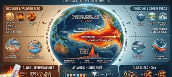
Fri, Aug 21 2026 /Mpelembe Media/ — The equatorial Pacific Ocean is currently experiencing a historic disruption in ocean-atmosphere dynamics as an exceptionally powerful El Niño event steadily intensifies. Measured by the Relative Oceanic Niño Index (RONI), which isolates localized ocean-atmosphere coupling from background thermodynamic warming to present a clearer picture of dynamical impacts, there is a 69% probability that the 2026–2027 cycle will rank as the most powerful El Niño on record since 1950. Leading seasonal forecast models show a remarkably consistent and intense warming signal, with sea surface temperature anomalies in the central-eastern equatorial Pacific’s Niño 3.4 region already running 2.6°C above the rolling average in August 2026 and projected to peak at an unprecedented 3.9°C anomaly in November. This extraordinary warmth far outpaces previous historical extreme events like the 1997–1998 and 2015–2016 episodes, with the UK Met Office declaring it a potentially “unprecedented” weather pattern that is likely the strongest in living memory.
This natural climate cycle is superimposing itself upon an elevated baseline of human-driven warming, which has turned the global ocean into a critical sink for greenhouse gas heat that is now being discharged back into the atmosphere. As a result, climate scientists project a 95% probability that the combined forces of this El Niño and anthropogenic warming will make 2027 the hottest year in recorded history. Average surface temperatures next year are expected to range between 1.67°C and 1.85°C (3.0°F to 3.33°F) above the pre-industrial average, temporarily exceeding the 1.5°C threshold of the Paris Agreement. This temporary acceleration compresses approximately 13 years of long-term warming into a single year, offering global policymakers and societies a stark, immediate preview of the average climate baseline anticipated in the late 2030s or around 2040.
Across the globe, severe atmospheric changes are reshaping precipitation and temperature patterns. The strong El Niño is responsible for a 55% probability of a below-average Atlantic hurricane season because of increased vertical wind shear that suppresses storm formation. In contrast, north-western Europe and the UK are set to experience an extremely wet, stormy autumn and winter due to wave-like tropical disturbances, even as regions close to the Pacific face contrasting disasters. Eastern Australia and South and Southeast Asia are experiencing severe drought risks and weak monsoons; Australian wheat acreage is expected to plummet, and India’s southwest monsoon is already running well below normal. Meanwhile, a complex “flood-famine cascade” is unfolding in East Africa, where the combination of this strong El Niño and a highly positive Indian Ocean Dipole is projected to unleash extremely enhanced, catastrophic rainfall during the October-to-December short rains season on top of already dry soils.
This atmospheric shock lands at a time of acute vulnerability for global markets, compounding a major geopolitical crisis in the Middle East where the near-total closure of the Strait of Hormuz has blocked approximately one-third of the global seaborne fertilizer trade. Securing nitrogenous fertilizer is highly time-sensitive for farmers, and these supply constraints are colliding directly with El Niño weather extremes. Consequently, economists and financial institutions project rolling waves of commodity-driven inflation, with Goldman Sachs estimating a 15.8% surge in global food commodity prices and the European Central Bank indicating that food prices could remain elevated for up to two years. The price of highly exposed soft commodities like rice, sugar, cocoa, coffee, and palm oil could skyrocket by 10% to 50%, and in extreme cases exceed 100%, threatening long-term macroeconomic stability and triggering “climateflation” that may force central banks to keep interest rates elevated.
The convergence of these compounding climate, energy, and fertilizer shocks is projected to trigger a severe global humanitarian emergency. The UN World Food Programme (WFP) and Food and Agriculture Organization (FAO) warn that this El Niño cycle is set to push at least 49 million additional people into acute food insecurity by the end of 2027. This represents a 22% surge in acute hunger across 45 analyzed food-insecure nations, driving the total number of acutely hungry individuals from 225 million to 274 million. The sharpest proportional increases and most devastating impacts are expected in Central America, where food insecurity could rise by 83.1%, as well as across rain-fed agricultural zones of southern and eastern Africa, and highly vulnerable populations in Asia and the Pacific.
A 13-Year Leap: Why the 2027 “Super” El Niño is a Discovered Map of the 2040s
The global climate has reached a threshold of undeniable “weirdness.” In 2026, the United Kingdom was scorched by its fifth major heatwave of the year, with London temperatures hitting a record 38.1°C. This wasn’t just a matter of discomfort; by August, the National Fire Chiefs Council had recorded a staggering 1,132 wildfires across England and Wales—a record high for that period. Simultaneously, the National Oceanic and Atmospheric Administration (NOAA) declared a 90% chance of a “very strong” El Niño. This is not a standard seasonal shift. The 2026-2027 “Super” El Niño is a climate time machine—a temporary atmospheric surge that offers a high-definition preview of our future.Our mission today is to explore the most surprising and impactful takeaways from this unprecedented event.
1. A 13-Year Fast-Forward into the Future
According to analysis by Berkeley Earth climate scientist Zeke Hausfather, the upcoming El Niño, layered over human-driven warming, has a 95% chance of making 2027 the hottest year on record. Current estimates suggest global temperatures could reach between 1.67°C and 1.85°C above preindustrial levels.This represents a staggering leap in the warming timeline. By reaching the upper end of that range, 2027 will experience temperatures that were not expected to become the baseline average for another decade. It is essential to note that 2027 is a spike, not a permanent plateau; as Hausfather notes, 2028 is expected to be cooler as the cycle fades. However, for twelve months, the planet will inhabit a climate normally reserved for the future. As Hausfather noted:”At the upper end of this range, 2027’s global temperature could resemble levels the planet might not otherwise reach until around 2040.”
2. The “Rising Staircase” of Temperature Records
One might expect global warming to follow a smooth, linear incline. Instead, the climate is moving in a “rising staircase” pattern. During El Niño years, the Pacific Ocean releases massive amounts of heat into the atmosphere, causing a sharp spike. When the cooling phase of La Niña follows, temperatures drop, but they never return to their previous levels.The “smoking gun” for this permanent baseline shift was 2025. Despite being a La Niña year—which should traditionally provide global cooling—it remained the third-warmest year on record, trailing only the previous record-shattering El Niño years. This happens because human-driven emissions are now adding a permanent El Niño worth of heat to the climate system every decade. Natural cooling phases can no longer offset the sheer volume of greenhouse gases, turning what were once “temporary” weather events into permanent shifts in the global baseline.
3. The Hurricane Paradox: Record Heat, Fewer Storms
The 2026 Atlantic hurricane season presents one of the most startling paradoxes in modern meteorology. Typically, record-breaking sea surface temperatures provide the “high-octane fuel” required for explosive tropical development. However, actual activity has remained shockingly low. The Accumulated Cyclone Energy (ACE) index—a measure of a season’s total power—sat at a meager 3.1 units, a fraction of the 1991–2020 average of 71–123 units.The mechanism behind this suppression is the “Super” El Niño itself. While the ocean is hot, the El Niño induces massive vertical wind shear and pumps Saharan dust across the Atlantic basin. These forces effectively “decapitate” developing storms before they can organize. Dr. Nick Dunstone and other experts at the Met Office have highlighted the extraordinary nature of these conflicting signals. Professor Adam Scaife, head of long-range forecasting, noted the rarity of the current data:”We should be clear that this is an unprecedented event… It will far exceed our recent experience of El Niño and its worldwide climate influences.”
4. Why We Had to Invent a New Yardstick (RONI)
In February 2026, the operational meteorological community reached a technical breaking point. NOAA officially replaced the traditional Oceanic Niño Index (ONI) with the Relative Oceanic Niño Index (RONI).The shift was necessary because background global warming has heated the tropical oceans so uniformly that raw temperature anomalies no longer provide an accurate signal. The traditional ONI was “drowning” in the noise of a warming planet. The RONI addresses this by subtracting the mean tropical sea surface temperature anomaly—calculated across the specific latitudinal range of 20°N to 20°S —from the Niño 3.4 region anomaly. This recalibration is a sobering admission from the scientific community: the oceans have gathered so much human-induced heat that we had to change how we measure “natural” cycles just to see them.
5. A Tale of Two Extremes: UK Storms vs. Australian Tinderboxes
The 2026-2027 event is producing geographically specific impacts that Professor Adam Scaife describes as the most intense he has ever seen in a forecast.
- The UK and Northwest Europe: There is an “unprecedented” signal for a significantly wetter and stormier autumn and winter. This follows the record-breaking summer droughts and wildfires of 2026, creating a high risk of flash flooding as intense rainfall hits parched, non-absorbent ground.
- Australia: Conversely, most Australian capital cities face an 80% chance of unusually warm and dry conditions. This is exacerbated by a “positive Indian Ocean Dipole,” a phenomenon that cools the waters in Australia’s northwest. When paired with El Niño, it creates a lethal “tinderbox” effect, mimicking the drought conditions that preceded the devastating 2019-2020 “Black Summer” bushfires.As Professor Scaife underscored: “I have never seen an El Niño signal this intense in our forecasts.”
Conclusion: The New Normal
The 2026-2027 “Super” El Niño serves as a stark warning that natural variations are no longer the primary drivers of our climate; they are merely passengers on a rapidly warming train. While the specific heat surge of 2027 will eventually subside, the greenhouse gases that allowed it to reach these record-breaking heights remain.As we approach the peak of this event, we must ask ourselves: Will 2027 be remembered as a freak historical anomaly, or was it the moment our futuristic climate officially became our new home?